Sunday, September 26, 2010

President and Accounted for Mount Rushmore and More, SD

Miles Driven: 150 (includes driving around Blacks Hills) September 11th Wasta, SD to Mount Rushmore, Crazy Horse and Custer State Park to Mount Rushmore, SD to Sundance, WY
Total Miles: 2362.3
Parking Fees: $10
Camping Fees: $0

Spent the morning driving through Wyoming to get to Mount Rushmore.  I reached the Black Hills at noon.  Getting to Mount Rushmore requires you to drive up into the snaking roads of the Black Hills.  Just as you round a corner the monument looms in the distance.  Now I don’t want to say I was disappoint, but maybe a little under whelmed.  I have seen many a photograph and it looks bigger in a picture than is does in real life.
Mt Rushmore Avenue of the Flags, SD
Don’t get me wrong, I believe that the monument is an amazing piece of art, its just smaller than I expected.  I drove further up the road to the entrance.  There is not an entrance fee but there is a parking fee.  Walking up the Avenue of Flags to the Grand View Terrace you see the four Presidents in all their glory.  OK, off the top of your heads who can name them?  You’ve got 10 seconds and no cheating go ……….From left to right, George Washington, Thomas Jefferson, Theodore Roosevelt and Abraham Lincoln.   I must admit I only got three of the four.  And they represent the birth, growth, development and preservation of the nation.

To early for a good photograph and the lighting ceremony I went off down the road (hills) to Crazy Horse.  Wow, Crazy Horse is massive compared to Rushmore.  Size wise, the four heads of the presidents will be able to fit into the hair of crazy horse.

Crazy Horse, Black Hills, SD

1/34th Model Crazy Horse Black Hills, SD
It has taken 50 years just to finish the head, now they are working on the horse.  As crazy horse is an active blast site, walking up to the mountain is prohibited.  Taking a $4 bus ride will get you to the bottom but the lines were to long.  The sculptor, Korezak Ziolkowski twice turned down $10 million dollars from the Government saying the memorial “is for the people, by the people“.  I hung around the view veranda taking photographs.  There is a 1/34th crazy horse model that you can get an idea as to how the finished memorial will look.  Thing is it will not be finished for at least another 100 years.  Taking a piece of rock I left and headed to Custer State park.

Custer State Park, SD
Custer State park is further down the road and is nestled in the Black Hills.  Not having much time as the sun was setting I came across a lake and took a couple of photographs of the sun setting over a ripped lake.  Not bad if I do say so myself.  Heading back to Rushmore for the lighting ceremony I was reminded of the day, September 11th.  There was an extra long ceremony and blessing for all soldiers past and present ending with the national anthem.  As I did not put my hand over my heart and sing, not American, I was spotted by another English couple, They were here on holiday and had just come from Yellowstone my next destination.  We are everywhere…

Mount Rushmore Light Up, SD


Needing to be on the road for awhile I drove for an hour so until I came across a rest stop.   The rest stop was just inside the state line in Sundance, WY.

Tuesday, September 21, 2010

In and Around the Badlands, SD

Miles Driven: 75 - September 10th The Badlands, SD to Wasta, SD
Total Miles: 2212.3
Camping Fees: $0

Waking up in the morning I felt parts of my sleeping bag where wet, so was my sleeping pads that where under a large blanket covering the entire tent.  The sun was out and it was windy.  Hanging everything up to dry in the camp shelter took awhile.  I threw the blanket over a couple of my car doors and waited for all to dry while I put the kettle on for tea and had breakfast.  Everything dried in about an hour.  The wind is great sometimes.

Drying Out After Heavy Rain Storm Badlands, SD
The Badlands are a place of extremes.  The summer is hot and windy with ever changing temperatures due to the fast rolling storms.  I had to sit in the car for hours while another rain storm rolled in and out.  I   drove to the Ben Reifel Visitor Center to chat with the rangers for the best places to take photographs.  While there I watched the movie and chatted with the rangers to find the best places to see bison (buffalo).  I stopped at almost every view point and took photographs.  Each place had something different to offer. Late in the afternoon I hiked up a rock formation and slide on the wet clay taking a nice rash to my right leg.  

Sun beginning to set I headed to the spot I spied the day before.  I had obviously picked the correct place as there was a professional English couple set up with their cameras too.  We chatted for a while waiting for the sun to go down.  I took about 75 photographs to get the “money shot”.  

Sun Setting Panorama Point Badlands, SD
Needing to leave the Badlands for my next destination I spied the moon raising over the rocks and had to stop and try my hand at getting a quick money shot there too.  You be the judge.

Moon Rising Over Badlands, SD
Nabbing the moon shot I left the Badlands and hit the road for a couple of hours.  I drove until I could not keep my eyes open any longer.  I pulled into a rest stop in Wasta, SD and spent the night in my car. The temperature was 55 degrees when I pulled over.  Wasta is off Interstate 90.  

Badlands National Park, SD are so Good.

Miles Driven: 24.7 September 9th Wall Drug, SD to The Badlands, SD
Total Miles: 2137.3
Entrance Fees: $15.00 (covered by America the Beautiful Pass)
Camping Fees: $14.00

Only minutes from Wall Drug, I entered the Badlands via the Pinnacles Entrance.  In another 10 minutes or so and around a corner, bang, your jaw drops and you almost drive off the road.  The Badlands are breathtaking. They appear out of nowhere. What you see is absolutely amazing.  It is hard to put into words what you see.  The Badlands are notched into the landscape in some areas, while in other places they grow up out of the ground.
Pinnacles Overlook Storm Approaching Badlands, SD

Pinnacles Overlook The Badlands, SD

Pinnacles Overlook is where I stopped and stayed for hours just taking in the sites with over 300 photographs.  In the distance, a storm was approaching, which made great scenic shots.  Some goats came wandering up out of the canyon and started munching on the grass growing around the parking area.  The males had  neck tags on to monitor their whereabouts.

Mountain Goats Pinnacles Overlook Badlands, SD
Lightening Bolt Camp Site Badlands, SD
As the sun was setting I drove further into the Badlands to look for a camp site.  Driving around the roads in the waning light looking at all the different kinds of rock formations gave me ideas on where to head out in the morning.  The storm was getting closer and closer and I wanted to get my tent up before it started to rain.  The wind picked up and I had to steak the tent and fly down.   As soon as the tent was up and secured the winds and rain came.  The storm, which looked great in the distance was not great in the here and now.  There were massive jagged bolts of lightening lighting up the sky.  The thunder vibrating off the rocks at times was deafening.  Trying to take a photograph of lightening is somewhat impossible.  My Nikon D90 wants to focus on an object before you can take a photograph, trying to focus manually on an object that is not there yet does not work.  So I opted to try with my little Sony point and shoot digital camera.  I had some luck, but again shooting in the dark waiting for lightening to happen is hard.  The shot I did get is a bit out of focus but it should give you an idea of the storm.

Raining for hours my tent was starting to leak in each corner.  Finding only socks in the dark I soaked up the water and rang it out in a plastic container, which I then had to empty out.  These actions were repeated well into the night.  Several hours later the rain stopped and I could get some sleep.  

Monday, September 20, 2010

Missiles and Drugs, Oh My!

Miles Driven: 340 September 9th - Brookings, SD to Minuteman Missile National Historic Site, SD to Wall, SD
Total Miles: 2112.6
Camping Fees: $0

Huron, SD

Brookings, SD is a big town compared to the rest of the towns I drove through on my way to The Badlands, SD.  I woke up to rain and cold around 55 degrees in the Wal-Mart parking lot.  On the road early, I watched the vast landscape of nothing between the little towns.  Huron, SD boasts they are the home to the world’s largest pheasant, in case anyone ever gets that question in a pub quiz.

Pierre, SD State Capitol
Prairies Pierre, SD 
Pierre, SD  the state capitol, on the other hand is where they filmed Dances with Wolves, again, good to know if you are ever in a pinch.  I was driving through vast prairie lands of undulating hills and I could image the scenes from the movie.  Once you leave Pierre there is a sign informing you that there are NO SEVICES for 68 miles, so make sure you check your gas level.  Not sure what I was thinking because I was on fumes after pulling into the gas station 68 miles down the road in Middletown, SD.

County Road 44, Philip, SD
Penelope (GPS) is set to use “least amount of highways” when I drive to a destination.  As a rule, I do not drive on the highways because I want to see the little towns of middle America.  But in this case I should have been driving on the highway as Minuteman Missile is just off Interstate 90.  As I was on Route 14 I was directed to go onto County Road 44.  Basically, a county road in that part of the state is a dirt track between fields of cows.  I drove down roads that were meant for tractors.  My wheel axels did not span the  dirt tracks and having to negotiate the roads was tricky at times.  Bumping down the roads I saw many hundreds of crickets jumping to their deaths on the front of my grill and windshield.  I stopped on a makeshift bridge to snap a photograph of a really gnarly looking dead tree.

Gnarly Tree County Road 44, Philip, SD
Ending at the Missile Site I was instructed that to gain access I needed to go back to exit 131 about 30 miles up the road.  Calling I found there was limited spaces and the dates had been booked for the next couple of weeks.  Instead I snapped a couple of photographs and made my way to Wall Drug.


By the time I drove into Wall, SD around 3pm the sun was out and I was famished.  Wall Drug, how does one describe this place?  I would call it an over glamorized small mall in the middle of nowhere.  Don’t get me wrong, it was very cool walking around the multiple stores looking at the over priced items for sale.  As soon as you enter the state you see signs for Wall Drug.  I started seeing signs 250 miles away.  The Husteads who own the store, moved into the back of the store in 1931.  The store did not do well for the first 5 years.  The summer of 1936 so hot and Dorothy Hustead had an idea to put up signs for free ice water.  The people who had been driving for hours came in droves.  This was the beginning of a legend in the making.  Anyone who lives in South Dakota will let you about the store.

Wall Drug Wall, SD
I headed straight to the Western Art Gallery CafĂ© for a hot roast beef sandwich with mashed potatoes and homemade gravy.   The sandwich did not disappoint.  Gravy was spilling over the edges and there was two huge lumps of mashed potatoes and the roast beef just melted on your month.  I finished off my late lunch with some soft served ice cream.

Stuffed Bison Wall Dug Wall, SD
Walking around Wall Drug I stopped in most of the stores just to window shop.  I did buy a t-shirt and picked up a free Wall Drug bumper sticker.  After spending 2 hours in the store and in the back yard where you can get your picture taken next to a stuffed bison and in a card board cut out of Indians in wigwams I was looking foreword to see the Badlands.

Sunday, September 12, 2010

Put it in your Pipestone, MN and smoke it.


Miles Driven: 49.5 - September 8th Pipestone, MN to Brookings, SD
Total Miles: 1772.6
Entrance Fees: $3.00 (covered by America the Beautiful Pass)
Camping Fees: $21.35

Dino drinking hot cup of tea, Pipestone, MN
The night was cold, very cold.  Waking up around 7am the temperature was 51 degrees.  I laid in my sleeping bag for another hour reading hoping it would get warmer.  When I finally poked my head out of the tent the temperature had risen to 60 degrees.  Time for a nice hot cup of tea and some breakfast.  Putting the tent away and packing the car I went to the office to pay and take a long, long shower before heading to Pipestone National Monument.    

The 15 minute long video explained the origins of the Pipestone (Catlinite) and its significations in today’s American Indian culture.  Pipestone can vary in color from mottled pink to brick red.  The stone is durable but yet relatively soft.  If you drop a carving it will probably break into pieces.  Specimens dating back 2,000 years have been found in Mound City, in today’s Ohio.

Petroglyphs, Pipestone, MN
The Pipestone location became the preferred place to quarry the stone around 1700 when Dakota Sioux controlled the quarries and only distributed the stone via trading.  

“Ceremonial smoking - rallying forces for warfare, trading goods and hostages, ritual dancing, and medicinal healings - marked the activities of the Plains people.”


Old Quarry Pipestone, MN
By the 1800’s pipes found their way into non-Indian societies through trade and effigies honored politicians and explorers; some caricatures where far from flattering.  Pipes and the Pipestone became a source of income for their makers and families.  To protect the Pipestone source from the White man, the Yankton Sioux secured free and unrestricted access by an 1858 treaty.  American settlement threatened to consume the square-mile reservation.  Outsiders were digging new pits and extracting the sacred stone.  In 1937 Congress established Pipestone National Monument to provide traditional quarrying for American Indians.


Quarrying today is very similar to how the stone was quarried in the past, by manual labor, brute force, sledge hammers, shovels, pry bars, chisels, wedges and picks.  No other tools are permitted in the sacred grounds for quarrying.  It can take anywhere from one to five years for an American Indian to gain access rights to quarry for the stone.

Oracle (Medicine Man) Pipestone, MN
Once you have gained access the real hard work begins.  Before one can get to the Pipestone there are several layers of hard Sioux Quartzite with visible cracks and fractures.  Once the Pipestone is exposed care must be taken to remove it.  The layer is only 14 to 18 inches thick, but only about 2 inches of that is ideal for carving pipes.  The Pipestone has natural fissures and must be removed layer by layer very meticulously.

After spending most of the day at Pipestone National Monument, the little town and writing post cards, I hopped on the road and drove to Brookings, SD where I slept in my car in a Wal-Mart parking lot.

Circle Trail Walk, Pipestone, MN


Saturday, September 11, 2010

Corn Anyone? IA

Miles Driven: 343.4 September 7th - Effigy Mounds, IW to Pipestone Monument, MN
Total Miles: 1723.1
Camping Fees: $21.38

Route US-75 Rock Rapids, IA
On the road again!  Iowa is flat, very flat.  There were fields upon fields upon fields of patch work quilted corn fields as far as my eyes could see.  The weather was getting warmer as the sun was bursting through the clouds.  At 2:30pm I stopped in the middle of nowhere and got out to take a photograph of the empty road, a pink road at that.

Route US-18 Waucoma, IA
There were mostly trucks and the occasional camper vans and RV’s on the road.  We were far out numbered by the trackers in various colors and sizes.  In-between the very small towns were tractor and farming equipment dealerships.  It was also nice to see wind turbines peppered on each new horizon.   And, of course there were silos, though the silos in Iowa were more stand alone than in Wisconsin.

Route US-18 Waucoma, IA
Arriving at Pipestone around 8pm I looked for a camp ground.  Just across the road from the monument was a family run camp ground off of Hiawatha Ave.  The office was closed, reading the self help information I found a tent site and pitched my tent.  Looking forward to stretching out instead of sleeping in my car.

Effigy Mounds, IA

Miles Driven: 0 September 7th - Effigy Mounds, IA 
Total Miles: 1723.1
Entrance Fees: $3 (covered by America the Beautiful Pass)

Arriving at Effigy Mounds visitor center around 9am I sat and watched the 15 minute movie.  The movie discussed the origins of the mounds and there meanings in the pass and present day Indian culture.  As the mounds are best viewed from above, many have speculated that the mounds were possibly religious sites or clan symbols used in seasonal ceremonies.   As there is no written record the berate goes on.  

There were several hiking trails to choose from all in varying lengths.  I opted for the north unit four-mile hike, which had "scenic view points" of the Mississippi river.  This included Little Bear Mound Group and Great Bear Mound Group.  The effigy mounds were built in four distinctive shapes.

Conical mound, Effigy Mounds, IA 
“Conical mounds, round domes of earth, are the oldest and the most numerous mounds in the area, dating back 2,500 years.  They are 2 to 8 feet high and 10 to 20 feet in diameter”.

Linear Mound, Effigy Mounds, IA
"Linear mounds, built between 1,700 and 1,300 years ago, were 2 to 4 feet high, 6 to 8 feet across, and could be 100 feet long”.

Compound mound, Effigy Mounds, IA
"Compound mounds are conical mounds joined by linear mounds.  They may mark a transition phase from conical to linear styles.  Groups of these mounds usually will have three to four linked conical mounds.  The largest group in the park has seven conicals and extends 480 feet.  Linear and conical mounds are found only in the Effigy Mounds region”.


Bear Mound, Effigy Mounds, IA
“Bird and Bear effigy mounds are predominate throughout the upper Mississippi region.  A typical effigy is 2 to 4 feet high, 40 feet wide, and 80 feet long.”

There were several scenic view points along the hike of the Mississippi river.  The day was overcast but temperatures were in the mid 60’s, great weather for hiking.  The conical and linear mounds were easily identifiable, but the bears mounds needed a more discerning eye.

Oh, if only I had been ten feet taller.  It is hard to capture the size and shape of the mounds in a photograph.  (Should have carried around a step ladder)  In the photograph above you walk up to the hind legs first.  The head is in the top left corner.  I stopped for a snack at one of the scenic view points and made it back to the visitor center in about 3 hours.  Back on the road to Pipestone National Monument, MN by 1pm.

Wednesday, September 8, 2010

Nothing but me, the road and SILOS

Miles Driven: 104 -  September 6th, 2010 Madison, WI to Effigy Mounds, IW
Total Miles: 1379.7
Camping Fees: $0

As you leave Madison, WI you notice how the landscape changes from urban to rural.  Gone are the strip malls and department stores and enter the farm houses and fields.  Now, I enjoy a nice farm house, but that is all I saw for hours, together with silos, thousands of silos, in all sorts of forms.  Short ones, tall ones, fat ones, thin ones, old ones, new ones, single ones, double ones, triple ones, quadruple ones, painted ones, rusted ones, gray ones, blue ones, granite ones, metal ones, rounded topped ones, flat topped ones, pointed top ones, plant covered ones and ever naked ones.  When multiple silos were together I would shout out “SILO ENVY.”

Silo Envy Dodgeville,  WI


Interlaced with the oodles of silos were the occasional wind turbines. From afar they look small, but as you get closer you can see that they are giant structures.

Wind Turbines Mt Hope, WI
                                                                                                      
I arrived at Effigy Mounds, IA just as the visitor center was closing, 6pm.  I asked about places to camp.  Yellow river was suggested.
 It was rustic camping about 20 miles away in the other opposite direction.  Not in the mood to drive that far of a distance, I asked Penelope to find me the nearest Wal-Mart just down the road in Marquette, IA.


Old Silos and Cow Farm Cobb, WI
The night was warm and a storm was brewing.  There were huge streaks of lighting and big drops of rain which lasted all of ten minutes and then it was over.

Veni, Vidi, Vici, Madison, WI

Miles Driven: 107 - September 6th, 2010 Lake Zurich, IL to Madison, WI
Total Miles: 1275.7
Camping Fees: $0

I came, I saw, and I went, is very true in regards to Madison, WI.  Before I drove into the city you notice all of the lakes in the state.  Little lakes, unlike Lake Michigan from whence I came.  Madison, WI the capital of the state is a stark contrast to Illinois’s state capital of Chicago.  Madison does not have any sky scrapers nor a subway system.  Madison is a college town, Chicago is a business town.  Upon heading to the city center you notice people, young adults, running everywhere.  Madison is home to the University of Wisconsin.  Madison is also a bicycle friendly city.  On most, if not all of the roads there are bike lanes.  And to prove this was not a waste of tax payers money there were many people, students mostly using those lanes.

State Building Madison, WI
Driving around the city of Madison I felt relaxed, unlike that of Chicago.  No one seemed to be rushing anywhere, except for the joggers.  There is a huge state capital, surrounded by other gray granite public buildings.  I particularly liked the state building office.  The day was warm but over cast with light rain throughout the day.

Night in the Windy City


Miles Driven: 41.7 -  September 5th, 2010 Chicago, IL to Lake Zurich, IL
Total Miles: 1168.7
Camping Fees $0

Having spent the day in the sun on foot, it was a pleasure driving around the city at night although navigating between the skyscrapers at times was difficult.  Penelope (GPS) at times had pinned me as being in the Chicago river.
Below the Sears Town, Chicago, IL
Windy City at Night Chicago, IL
After a long day and part of the night I left the city and headed to my next destination, Madison, WI.  Knowing the drive was about 100 miles away and there would not be a camp ground anywhere near or around Chicago, I opted to drive out to Lake Zurich and find a Wal-Mart.  I pulled into the parking lot about 11pm.  The night air was cool as I prepared my car for yet another day of sleeping in.

Monday, September 6, 2010

The Windy City, Chi-Town, IL

Miles Driven: 37.2 - September 5th, 2010 Joliet, IL to Chicago, IL
Total Miles: 1127
Camping Fees: $0

So much to see and do in Chicago.  First on my list was to travel there by ‘L’ Chicago’s name for the CTA train system, due to the fact it is elevated.  Parking my car in a park and ride parking lot I was driven to the Midway train station where I hopped onto the waiting train.  

Midday 'L' Stop
One of the great things about any train/subway/tube system is the ease of use.  Buy a fare card, head to the correct side of the train tracks, get on, listen to your destination, get off at that stop, and bang, you’re there.  Chi-Towns ’L’ was no different, save one thing.  As the city loomed in the distance, getting closer and closer as the train drew nearer and nearer, one would expect it to vanish before your eyes as you went underground.  Not so on the ’L’.  As the tracks are elevated you get to see the city in all its glory from beginning to end. 

I got off at Quincy and strolled around looking at buildings and architecture until I hit State Street.  I called it Chi-Town’s Georgetown because of all the retail stores.  

Chicago Theatre on State Street
Remembering to look up as I came to buildings was forgetful at times.  Not being used to a skyscraper city.

Chicago Skyscrapers
You had to admire the buildings from a distance as supposed to being right underneath them.  So I headed to Millennium park.  I entered the park via Washington Street.  To the left was Wrigley Square and Millennium Park Monument.
"The monument
Millennium Monument
is a nearly full-size replica of the peristyle which was originally in the same location between 1917 and 1953.  The columns are made from Indiana limestone.  In appreciation of the park‘s founders, their names are etched onto the base. ” 

Looks very similar to Greek columns to me.

Next I strolled over to the AT&T Plaza/Cloud Gate.  Very odd indeed.  I’m calling it the giant bean, well because that’s what it looks like.

“The 110-ton elliptical Cloud Gate sculpture is forged of a seamless series of highly polished stainless steel  “plates”, which reflect the city’s famous skyline and the clouds above”.

If you look very closely at the picture of the “bean” you can see me taking the picture.  Not sure what I think of the sculpture, other than it was the first of Anish Kapoor’s first public outdoor work installed in the US, and oh by the way he is a Brit.

When one is in the Windy City one has to eat like a Chicagoan, meaning deep dish pizza.  I asked a local visitor center employee if she was going to eat one where would she go, Giordano’s.  With directions in hand off I went in search of the authentic deep dish pizza.  I was not disappointed.  I eat the whole thing along with a beer. (Can’t have pizza without having a beer)  It was good, no, it was everything I thought it would be and more.  I’d like to say I savored every mouthful, enjoying each piece of spicy sausage oozing with cheese and marinara sauce, so I won’t, I devoured it.  

Chicago Sky Line

Between two Chicago Buildings
After inhaling my food I was in need of a walk, off to Navy Pier where I sat and enjoyed the breeze off Lake Michigan.  Could not ask for a better day, with temperatures hovering around the high 70’s.  By this time the sun was beginning to set and the breeze off Lake Michigan was getting cooler.  Now I know why it is called the ’Windy City”.  In the summer it is great, but in winter I believe I’d hate it.   So I headed back to the ‘L’ and the warmth of my car.  I drove back into the city to take some shots of the sky line all lit up, as it was on route to my next destination of Madison, WI.

Sunday, September 5, 2010

Indiana State Park, IN

Miles Driven: 336.1 - September 3rd  Mammoth Cave Park KY to Indiana Dunes National Lakeshore, IN
Total Miles: 1050.6
Camping Fees: $0
Entrance Fee: $10.00

Spent the day at Indiana State Park on Lake Michigan today.  Fabulous day, sunny with temperatures around 80 degrees and very blustery.  Swimming was not permitted due to the rip tides.  So I ambled around the shore line with my feet in the water.  Later in the day I sat in my camp chair and read my book and people watched.
Right Foot in Sand, Indiana State Park, IN

Dino Reading Book, Indiana State Park, IN

You could see Chicago off in the distance, my destination on Sunday, September 5th.  As the sun was being to set, I retrieved my camera and tripod out of the car and started to take pictures.  It is funny very how a tripod gives the impression of a professional at work.  I am hardly a professional photographer, amateur at best.  But having the tripod makes for good conversation and this I am really good at.  No, I'm not with a paper or news crew, just here and vacation.  Doing a cross country road trip.  Funny how many people are so jealous of the idea.


Chicago in the far ground, Lake Michigan in the middle and Indiana State Park in the foreground, IN

Time to find a camp ground after the sun had set.  Penelope gave me several camp grounds to chose from.   I called several before I found space.  I headed for Joliet, Il just outside of Chicago.  Never did find the place.  Not sure if it was me or Penelope.  So after driving around for 30 minutes I headed to the nearest Wal-Mart parking lot, again.  This happened to be a Sam’s Club, same company though.

.

Saturday, September 4, 2010

Indiana, here I come

Miles Driven: September 3rd 366.1 Mammoth Cave Park KY to Indiana Dunes National Lakeshore, IN
Total Miles: 1050.6
Camping Fees: $0

Another full day of driving, driving, and driving.  Saw a lot of the countryside, flat as flat can be.  Drove up I64 for half the trip then on local roads.  Drove through the capital, Indianapolis, busy, but easy to navigate.  I have found though, Penelope is much better while driving at faster speeds then she is at slower.  I am on top of a turn before she barks at me to turn.  But never mind, we all have our weaknesses.  My destination is at the top of the state between Gary and Michigan City on Lake Michigan.  I drove through all of the state to get here.  It was dark by the time I arrived and the Indiana Dunes National Lakeshore camp ground was full.  This is where Penelope came to the rescue.  The nearest camp site was too far away so I opted to sleep in my car in a Wal-Mart parking lot in La Porte, IN.  There were several other camper vans around the huge lot.

Taking it very easy today.  No long hours of driving.  Heading out to the Dunes.  Will update this post later with pictures.    

Mammoth Cave, Kentucky

Miles Driven: September 2nd  374.1  New River Gorge, WV to Mammoth Caves, KY
Total Miles: 684.5 Camping Fees: $17.00

Sleeping in a tent by the river was great, just me, butterflies, gnats, mosquitoes, birds, fish, frogs, beetles, ants, cicadas, and trains, no, not a mistype.  Trains, all night long.  Loud and long.  The train tracks were just across the river, less than 100 feet away.  Nothing beats a peaceful night of nature than a long loud train in the middle of night.

Morning on the New River, WV 
Got up super early and found hundreds of red ants crawling over the tent.  Luckily only a very few found there way into the tent.  Took some pictures of the river as the sun started to burn away the mist.  Quite, very quite.  Watched as a blue heron came into land on a huge rock not far from where I was standing.

Blue Heron, New River, WV
Put the kettle on for some tea, (By kettle, I mean the stove and a little pot of water) while I started to pack away the tent.  Being down in the valley there was no cell service and Penelope (GPS) was very slow at pin pointing my location.  (Either that, or she thought I was lost)  Headed back up the mountain to start my drive to Mammoth Cave, KY.
Drove through Charleston, the state capital of WV, very pretty town.  Penelope wanted me to drive around a mountain which would have added another 100 miles to my drive time.  I opted to take a highway to avoid the time and mileage.  Good decision on my part.  Drove through Lexington, KY at rush hour on a holiday weekend, not a good decision on my part.  Oh well, can’t win them all.

Entered Kentucky, first of my new states to visit on my cross country road trip just before lunch time.  Filling up at a gas station I would pay cash and chuckle at the local accents.  Because I took local roads I happened upon Abe’s boy hood home in Hodgenville, KY.  That’s President Abraham Lincoln to you all.  He and his family grow up in a house (if that’s what you can call it) in a small farm called Knob Creek Farm.  I then drove to his birth place just up the road, Abraham
Lincoln's Boyhood Home, Knob Creek Farm, KY
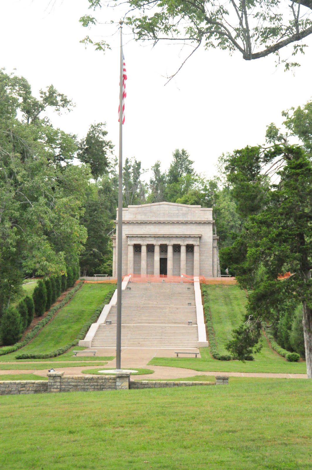
Lincoln Birth Place and National Historical Park.   The memorial building protects the symbolic birth place cabin which happened to be off limits that day.  Had to enjoy it from afar.

Memorial Building
Filling up at a gas station I would pay cash and chuckle at the local accents.   Arriving to late to visit the caves, I camped at the National Park Service of Mammoth Cave, KY.  Tired from driving I pitched my tent and eat dinner.   A moderate campsite with running water and an air conditioned bathhouse.  What perks!  Being a popular camp site there was very little dead wood lying around.  Could only have the campfire going for about an hour before I ran out of wood.  But that was all I needed as the days drive wore my out.

Thought I got up early at 7am and eat breakfast and packed everything away by 8:15am.  Stopped by the camping office to pay and chatted with the ranger.  But to my surprise when I entered the Mammoth Cave National Park visitor center I had to wait for it to open at 8am.  Yep, I was in central standard time and not eastern stated time.

  1. Niagara Falls, Mammoth Caves, KY
I chose the 2-hour New Entrance Cave Tour for $12.00 stated as ‘moderate difficulty‘.  The temperature year round is about 58 degrees.  There were some tight places to walk through but nothing that bad.  Upon entering you had to walk down stairs, 280 on the initial descent 250 feet down.  One has to marvel at the construction of the steps.  The steps took 20 years to complete and the park went through 3 contractors to finish the job.  The first contractor wanted to have the steps worked into the rocks, and not the rocks around the steps.  The second contractor under bid the job and went bankrupt.  The third and final contractor was a submarine stair engineer specialist.  The job only cost $3,000.…………..................................... per step.  Remember, there are 280 of them.  You do the math.  Our tour guide was great and very amusing.  She turned the lights off and give us the experience of how the caves naturally.  Dark, complete blackness.  Could not see a thing, nor could you hear a thing.

Some of the names in the caves: Grand central station, Grand Canyon, Grand Central station, frozen Niagara, Rock of Gibraltar.  These names were given to formations in the cave to attract visitors.